
Seamless Neighbourhood
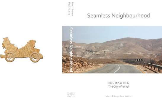
Seamless Neighbourhood – Redrawing The City of Israel
“…Cities do not politically or geographically, begin or end at municipal borders. Tel Aviv is both a “municipal city” of four hundred thousand and a national metropolis of three million people. This is a fractured and atomised landscape that encompasses the tolerance and prejudice, vulnerability and fragility – seen and unseen – of urban life. It is an infrastructure of physical and social architecture that exists in seamless visible and invisible boundaries..”
Seamless Neighbourhoood – Redrawing the City of Israel will be published in 2018
The following article is an extract from The Seamless Neighbourhoood
INTRODUCTION
Seamless Neighbourhood – Redrawing the City of Israel is a story of a city. That city is Tel Aviv. The story of any city, fact or fiction, is inescapably entwined with the author’s own perceptive. Every author’s story necessarily reflects and encapsulates his or her particular interests, drafting and editing choices. it is illusory that an author can escape the path of subjectivity. What is not included in a particular story can often attract greater attention and generate a critique a case of admission by omission.
The choice of subject for inclusion in this book reflects our academic background in geography, economics and fine art and our working knowledge as a practicing architect and urban planner. This is not to suggest to the reader that what follows is a deeply personal, revelatory journey, but as authors, the collection of observations that generate the story of this book is shaped by our personal experiences and is indivisible from our personal interests. We have endeavoured to creatively blend the diversity of this experience into an interdisciplinary framework of inquiry.
A frequent theme that unites the subject matter in this book is the desire to uncover stories of invisible landscapes, and to reveal the seamlessness of those inhabited geographies.
Landscapes, and in particular man-made landscapes (where we build, what we build, where we ought or ought not to build, who lives where and why and how we travel) all form part of the basic building blocks of everyday inquiry for architects, planners and urban geographers. Landscapes are of course not just designed; they are primarily personally lived, experienced, consumed, tasted even. Their stories are particular and peculiar to each individual.
We read our own everyday landscape according to a vast and complex ever changing, bewildering array of often competing and often contradictory information. much of it is personal to us. much of it is informed or determined by our ‘place’ in society – what we do, where we live, who we know, our age, economic choices (or lack of them), ethnicity and legal status. While each of us generates our own mental map of space, the autonomy of our actions, our daily movement, can and often is unknowingly determined by others. every day we make illusory choices from a supposed myriad range of personal options.
We simultaneously juggle different social roles and relationships – family, work, friends, neighbour, anonymous resident, citizen – and also navigate both literally and symbolically a hierarchy of different scales in our everyday lives. This includes everything from the immediacy of the walk to the local neighbourhood store, the sense of distance of travelling across the city, right through to the imagined geography of the nation state we live in. That awareness of diversity of scale and space includes an obvious sense of where we are physically, right now, at any one moment in time. it also includes how and when we visualise, imagine, even momentarily, where others are and what they may be doing. This constant back-and-forth flux, an ever-expanding and contracting imagined, real and negotiated space is how we all live, how we all operate consciously and subconsciously in our habitation of place.
Whilst there is nothing insightful or original about these observations, they provide a framework for how this book is structured. what we see and what we don’t see, what we choose not to see or what is very consciously hidden from us, how we read, interpret or navigate our everyday landscape, real or imagined, is central to the unfolding journey of this book. in Seamless Neighbourhood we endeavour to reveal an obviously tiny slice or fraction of those landscapes.
The structure of the book, in some ways, is an accordion-like experience of how we imagine and experience space a constant back-and-forth journey, expansive then compressed, expansive again.
Just as an architect in a design exercise may quickly go from the scale of an apartment layout a kitchen, the location of a window to a particular view to a neighbourhood scale of 500 housing units, every one of us lives and imagines, all of the time, differential scales of space, but in a less self-conscious or structured way. our geography of scale, of space is utterly seamless. from deconstructing (or living) the sociability and functionality of a Tel Aviv balcony space to imagining (or driving through) the invisible whereabouts of a quasi-Palestinian autonomous state, our experience and imagination of scale is simultaneously always 1:1, and occasionally an unknowable, unfathomable or fantastical 1:1000 or 1:1,000,000, one scale compartmentalised and enclosed, yet simultaneously overlapping with another that’s a parallel bird’s-eye view and Cinema- scope in perspective.
An additional commonality of approach to the content of many chapters is an exploration of the seeming banality of data, particularly hidden or unimagined data. It’s about making connections, decoding or quantifying landscapes. imagining numerical space whether it’s calculating the totality of balcony space in Tel Aviv or measuring the distance of Rothschild avenue to the West Bank, mapping the homes of Knesset members or drawing the ‘invisible’ ethno-gerrymandered constituencies of settler electoral geography is part of the reality of the seamlessness of ordinary Tel Avivian city life in the midst of extraordinary Israeli political exurban geography. Imagining and quantifying hitherto unimagined space can create additional appetites or layers of enquiry, alternative ways of looking. it can open minds, provoke questioning.
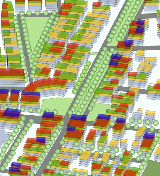
Section of Tel Aviv Boulevard
Excavating the layers of a profoundly contested historical and geographical landscape to expose the myth-making of national narratives around everyday built environments is a common thread throughout the book. There are few books on Tel Aviv that substantially discuss the Israeli occupation, and few books on the occupation that meaningfully discuss Tel Aviv. This disguises the world Tel Avivians and other Israelis inhabit. A goal of Seamless Neighbourhood is to not simply blur the boundaries that separate these two domains, but to reveal the reality that they are not so self-contained.
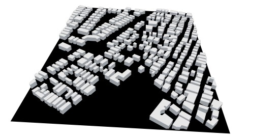
Section of Tel Aviv – Negative Positive Space
In this way the book can be viewed as a synthesis of a certain Tel Avivian narrative that emphasises what we call either ‘The historic here’ or ‘The Contemporaneous There’ spatial critique of the Israeli-Palestinian conflict with respect to the city of Tel Aviv. The narrative of ‘The historic here’ is a critique of the myth-making surrounding the origins of the white City of Tel Aviv, the myth that Tel Aviv emerged from the empty dunes or sand of the Mediterranean coast.
The narrative of ‘The Contemporaneous There’ is a critical exploration of the settlement project and its architectural geography today, an architectural geography that is, however, largely viewed as separate, at a distance, over there, somewhat removed from the city of Tel Aviv. whether ‘over there’ (15km to the ‘green line’ and beyond it) or ‘back here’ (100 years past).
‘The Historic Here’ and ‘The Contemporaneous There’ narratives are both inevitably distanced by either space or time. Political reflections, indeed moral responsibilities, are somewhat denuded or mitigated by the distance of history or geography. history and geography have partially, perhaps conveniently, absolved the city. Tel Aviv as a city has embraced a sense of self that is guilt-free. history and geography have colluded to generate a bubble of protection for self-identifying cosmopolitan Tel Avivians.
It’s as if a Tel Avivian attachment, an affinity, a love even, of this liberal city somehow absolves. Politics is something else, it’s elsewhere, it’s over there.

Tel Aviv Section – Sea – Beach – Promenade – Hotels – Boulevards
The reality of a seamless metropolitan urban Tel Aviv geography that includes settlements is largely viewed as apolitical.
Seamless Neighbourhood can be viewed as a partial synthesis of ‘The historic here’ and ‘The Contemporaneous There’ to frame the discussion around what we call ‘The Contemporaneous here’. This, in the context of Tel Aviv, is the reality of a city whose residents and commuters, shoppers or day-trippers, work and reside in an urban metropolis whose functional (geographic, social, economic) boundaries do not readily recognise the borders of the 1949 armistice (green) line. In this way, ‘greater Tel Aviv’ can be understood, for Jews at least, as a vast, albeit differentiated, but seamless neighbourhood. greater Tel Aviv, with a population of 3.6 million people, is now home to more than 2 out every 5 Israelis.
This is a metropolitan conurbation that extends from Netanya in the coastal north to Ashdod in the coastal south. To the east, its metropolitan functional grip extends inland and uphill into the suburban commuter Israeli settlements of Alfe Menashe and Elkana across the green line. Some 20% of the residents of Ariel, an Israeli settlement which lies 17km inside the west bank, commute to greater Tel Aviv. This seamless neighbourhood includes approximately 10% of all Israeli settlers, or greater Tel Avivians, who reside in dormitory suburban settlements over the green line inside the West Bank.
Throughout the book we use the terms ‘greater Tel Aviv’, ‘the Seamless Neighbourhood’, ‘Contiguous metropolitan’ and ‘the city of Israel’ interchangeably.
So how big is Israel’s largest city? how big and small can we make it? how elastic are its borders? in Chapter 1: ‘Does Size Matter?, we ask where does Tel Aviv really begin and end, and explore why the multiple answers to that question are so important to our understanding of the seamlessness of Israeli political space.


Distance Comparative Map – Dublin – Tel Aviv and London – Tel Aviv
‘Contiguous Tel Aviv’ maps out a contiguous belt of density, radiating out from the heart of downtown Tel Aviv (a minimum population of 200 people per km2), to reveal a metropolitan reach into the occupied west bank. The capacity to try to look at a map, any map, differently and imagine the making of new geographies is an age-old cartographic game. in ‘The “Lie” of the Land and the Lazy Eye of Geography’ we inverse, reverse, re-orientate and overlay various homemade Tel Avivian geographies to reveal their relative size to other global cities.
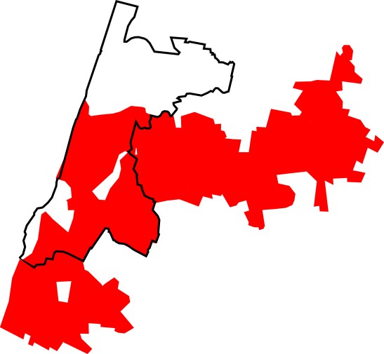
Contiguas Population density Tel Aviv
‘Does Size Matter?’ suggests that immigrants from the former Soviet union (a country 10,000km wide) may in part be attracted to the politics of a ‘greater Israel’ espoused by the Russian-dominated political party Yisrael Beiteinu after having absorbed the startling reality that their newly adopted home state is a mere 14km (9 miles) wide at its narrowest point. That narrowest point is just 5km north of the municipal border of Tel Aviv-Yafo.
In Chapter 2 we explore the DNA of the city by decoding land-use zoning and open-space hierarchies. we also map and photograph the multiple identities of the white City of Tel Aviv. ‘508 Immutable Zonings’ reveals some of the 508 different zoning ordinances to be found in the Tel Aviv-Yafo municipal city plan, and asks who is empowered with the authority to alter, or invested with the skill to persuade those with the power to alter, these apparently immutable zonings. more importantly, who benefits from the opacity of this power of alteration?
Chapter 3 deconstructs and reconstructs various Tel Avivian built landscapes. in ‘Balcony Space’ we trace the evolution of the balcony in the social urban history of the city of Tel Aviv, exploring how the variation in taste of the Tel Avivian balcony has captured or reflected the contemporaneous zeitgeist of the Israeli state.
‘Eleven and a half Rothschilds’ explores how Rothschild boulevard occupies not only an important centrality of place in the geography of Tel Aviv, but also performs a meaningful hub for a very particular Tel Avivian mindset. in a celebratory challenge to that mindset, an imaginary Rothschild boulevard is unfolded from the centre of Tel Aviv eastwards until it arrives at the ‘front door’ of the green line that separates Israel from the West Bank.
Chapter 4 explores the exurban geography of greater Tel Aviv with respect to the occupied West Bank. ‘The Exurban Geography of Tel Aviv – Alfe Menashe’ examines the multiple landscapes of the seamless suburban and exurban ‘settlement’ geographies on the fringes of metropolitan Tel Aviv. The six ex-urban geographies – ‘green line’, ‘google’, ‘identity’, ‘Picturesque’, ‘windscreen’ and ‘Security’ – each reveal their own stories; collectively they endeavour to present a picture of the multiple identities and the complexity of the seeming banality of the Israeli suburban dormitory landscape.
A seamless geography is a de facto uncertain geography, in the sense that Israelis are at times not quite sure of the geography of municipal or national borders,
….including the location of the green line. few residents of any city notice when crossing municipal bound- Aries. Israelis are, however, often unclear as to where and when they cross the internationally recognised border between Israel proper and the West Bank. That uncertainty can fuse with a kind of equanimity and unknowingness when travelling across the open desert landscape of the West Bank.
In ‘The Tel Avivian Dead Sea Drive’ we take a Tel Avivian journey of day- trip geography. This is recreational travel into the occupied west bank that is largely stripped of political meaning for its day-trippers. This is a day-trip geography that almost all Israelis have undertaken at some point in their lives. The Tel Avivian dead Sea drive is often very temporary; one’s presence in the west bank is almost fleeting – a few hours, a couple of days, perhaps just a few times over a number of years. yet this apparently everyday recreational journey is woven into a more complex reality of the seamlessness of the Israeli occupation.
It is this ordinariness of the lived experience of the occupation that we would argue psychologically anaesthetizes an Israeli (primarily Jewish) understanding of the occupation itself. The municipal borders of Tel Aviv may be fixed, but the recreational boundaries of Tel Avivians are politically and conveniently blurred.
in ‘Seamless Segregation and Greater Tel Aviv’, we reveal that the 49 Jewish small villages or communities of greater Tel Aviv inside Israel proper are, in fact, fractionally more homogeneous and segregated than Israeli ‘Jewish only’ settlement communities inside the occupied west bank. This subliminally known patchwork pattern of ‘Jewish only’ or ‘Palestinian only’ villages and towns within Israel proper may partially inform the perception and thus possibly a residual passive acceptance of the continuation of the occupation in the west bank amongst Israeli Jews.
‘An Israeli City over the Green Line’ asks when is a ‘settlement’ not a ‘settlement’? we explore how the fact that the majority of the 650,000 to 700,000 Israelis who live beyond the green line reside in neighborhoods and suburbs of Jerusalem and greater Tel Aviv serves not just to legitimise the Israeli settlement project, but more remarkably facilitates a linguistic political metamorphoses.


This is a metamorphoses that allows a settlement to evolve and mutate, to literally outgrow and somehow ‘un-become’ a settlement, and yet simultaneously remain geographically over the green line.
Chapter 5 makes visible Israeli invisible geographies. in ‘The Road to Ariel’ we drive the seamless, uninterrupted journey along route 5 motorway from the beachfront in Tel Aviv to the settlement city of Ariel. This is a journey that takes no more than 30 minutes. it is a journey of invisible geography, a high-speed, rarely congested, almost endlessly straight motorway connecting Israel proper with Ariel, almost halfway across the West Bank. This is a motorway with no signposts to tell you the names of local Palestinian towns and villages because there are no motorway exits to access them. They lie in forbidden territory. The motorway is designed not to connect to this invisible geography.
The invisibility of boundaries or absence of borders and constituencies masks the reality of other profound geographies. in ‘Constituency Geography’, ‘What if the Knesset went local?’ argues that the absence of a local area-based or territorial link to local elected councillors in Tel Aviv may not strike Tel Avivians as peculiar for the simple reason that in Israeli national elections the electorate votes in a single electoral constituency. This uniquely Israeli singular electoral geography has the effect of neutralising Palestinian political geography. The Palestinian voting bloc, indeed like all Israeli political groupings, are, whether by accident or design, literally ‘geographically invisible’ on election night.
In ‘The Shifting Ideology of a Simple Map’ we contend that, in recent years, historical and self-conscious left-right cartographic map-making badges of identity have strangely started to mutate, reverse even. where once to draw the contours of Israel as bounded by 1967 borders was perceived as an exercise in left-wing cartography, now it only serves to perpetuate the myth of two nations, Israel and Palestine, or, more perverse still, two Israel’s the first, an imperfect but essentially democratic Israel that subscribes to western political norms and operates inside the green line, the second, an undemocratic Israel, a segregating and occupying military force that governs in the occupied territories.
Irrespective of the application of two different legal jurisdictions (civilian and military), there is (and has been since 1967), of course, only one single de facto ‘sovereign’ state operating between the Jordan river and the Mediterranean Sea.
Every country perpetuates its own territorial myths through map-making; few perhaps are afforded the luxury or opportunity of designing myths on the scale of mini Israel. Mini Israel was built at a scale of 1:125 to be precise, and extends over 35,000m2, housing 350 large-scale models and buildings. in ‘Mini Israel’ we walk the miniaturized toy-like representation of the state of Israel where there are no borders, no settlements, no west bank. The ‘separation barrier’ is conspicuous by its absence; there is no green line.
The increasing invisibility of the green line for many Israelis serves to erode or erase the geography of a future Palestinian state. in ‘Butterfly State’ we pin down six varieties of real and imagined butterflies to be found locally in Israel-Palestine.
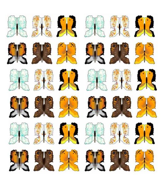
Butterfly Stat
‘Butterfly State’ seeks to create a visual appetite to look again, to look harder, to question one’s assumptions, to open one’s mind. which butterfly states are real or imagined, natural or manmade?
What can we see? what do we choose to see and not to see, and can invoking the temporal beauty of the butterfly reveal the tragedy of spatial stories and journeys we have chosen not to navigate? ‘Butterfly State’ is not simply a game of fantasy geography.
The increasing invisibility of the green line in the life of most Israelis, and the increasing visibility of a separate proto-Palestinian state (a parliament in Ramallah, the trappings of government, a national separate vehicular licence-plate system) paradoxically serve to validate the existence of a quasi- Palestinian state and simultaneously consolidate the occupation. This is a quasi-Palestinian state that is somewhere ‘over there’, not quite geographically discernible, but nevertheless a state that is almost politically tangible.
It’s this vague sense of ‘somewhere-ness’, we would argue, that assists in masking a comprehension of the reality of the contours of the geography of the occupation. This is a Palestine that somehow manages to operate in a sort of schizophrenic duality.
On the one hand, this is a Palestine that is hidden (behind walls and checkpoints); it exists but is not seen. This is a Palestine that Israelis are forbidden by law to visit (area a under the Oslo accords). on the other hand, the illusion of a Palestine state is promoted. It includes the superficial trappings of a state with a parliament in Ramallah. This Palestine is allowed to be seen but is not permitted to exist (as an independent state).
Equally invisible on the evening weather forecast are the Palestinian cities of the West Bank. Every major daily (Hebrew) national newspaper and all major national TV channels use a map of Israel in weather forecasts that is devoid of the green line. in Yedioth Ahronoth, Israel’s largest selling daily newspaper, all major Palestinian population centres in the West Bank are omitted from the weather map. This omission, one could argue, is reasonable, as these Palestinian cities are ‘technically’ not inside Israel, nor have they been officially annexed by the Israeli state. The same, however, is true of the settlement city of Ariel.


The weather maps all include Ariel, which is a sixth the size of the adjoining next-door Palestinian city of Nablus. Nablus is invisible on the Israeli weather forecast. This invisibility of Palestinian geography has a complex relationship with the consumption of the Israeli occupation.
There is a common and somewhat peculiar perspective amongst many on the Tel Avivian Israeli left that, in terms of the land, the majority of Israelis haven’t really assimilated the settlements into their concept of Israel’s territory in their everyday lives – that they, Israelis, don’t go there; they have no wish to go there; ‘there’ becoming the almost unspeakable, unnamable ‘territories’. This narrative presumably is intended to generate a sense of political comfort, detachment, a kind of hopeful or willful disengagement, an almost psychological resistance even. what this often can simply mean is ‘people like me’ or ‘the people I know’ choose not to go there.
There is a risk that this left- wing Tel Avivian world view is erroneously extrapolated for the nation as a whole. Perhaps if a majority of Israelis don’t go there – the settlements that is – it’s simply because a majority have no reason to do so. They may have no family or work connections there. it may sound logically trite, but it is nevertheless true to say that, geographically and statistically speaking, the majority of people of any country do not actually go to vast swathes of many parts of the country they inhabit if they have no reason to go.
The political detachment, distaste even, for the settlement project among wealthy north Tel Avivians is partly nurtured, we would argue, by the reality that few wealthy Tel Avivians are likely to have family or friends seeking cheaper, more affordable homes in those distant suburban settlements.
Privilege and housing choice can accidentally inform, perhaps conveniently reinforce, attitudes to geopolitical geography.
And where exactly is ‘there’? The separation of the settlements themselves from the occupation or control of wider open territory often betrays muddled thinking. one doesn’t actually have to visit a settlement per se, pass its security gates, to consume the geography of the occupation. The Tel Avivian day-trip drive to the dead Sea is a visit through the occupation itself. it is a day-trip geography consumed by many Tel Avivians leftists. and if most people do not travel to many parts of the occupied territories, maybe the reason is rather prosaic – they are forbidden or it’s unsafe to do so, not because they are consciously acting out some form of personal political disengagement plan. Many Israelis living close to the Palestinian city of Qalqilya visited the city in the 1980s to shop, to go to the market. They do not go there now because the city is surrounded on three sides by an 8m-high wall. it’s illegal to go there, and it is probably unwise to do so.
We would argue that Israelis do assimilate or consume the geography of the occupation in their everyday lives. and they don’t have to travel to a settlement to do so. The fact that every major newspaper and every TV channel presents a single Israeli geographic space, devoid of the green line and devoid of Palestinian cities, in their weather forecast maps is a not-so-subliminal and powerful message in normalising one continuous Israeli space.
It is the very seamlessness of the occupation that in part serves to sustain it. it psychologically anaesthetizes an Israeli (Jewish) understanding of the occupation itself.
The Israeli occupation of the west bank entered its 50th year in 2017. The political, economic, ethno-cultural and militaristic forces that weave together to sustain that occupation are undeniably complex. in Seamless Neighbourhood we identify two cartographic and apparently contradictory forces at work which paradoxically and simultaneously assist
in sustaining that occupation. on the one hand there is the conscious willful decoupling of Israel and the west bank in mental mapping, and on the other an erosion or erasure of the green line on the ground and in map-making between Israel proper and the West Bank.
This is complex parallel and simultaneous process of psychological separation and physical integration. The imagined decoupling in map-making is fed by a leftist desire to separate, to disengage or withdraw from the West Bank. it perpetuates a myth of two Israeli states. This is an Israeli state west and east of the green line.
The concept of an Israel proper and an occupied West Bank sustains a political illusion that there is ‘a here’ and ‘a there’.
This is the illusion perpetuated by many on the left of a democratic Israeli state west of the green line and an ethno-segregated occupied or undemocratic Israel state east of it.
The constructed narrative of a ‘democratic’ motherland state and an ‘undemocratic colonial’ or client state may have some conceptual validity if they were separated by an ocean or continent. The seamless reality, however, of Israel and the occupied West Bank renders this constructed narrative somewhat senseless. This ongoing mirage of the decoupling of Israel proper from the west bank is in part fed by the delusion of an occupation that is an interim or temporary arrangement. fifty years of occupation in the life of a nation state just 70 years old is anything but temporary.
In Chapter 6, we reflect on the political state of the ‘State of Tel Aviv’ and the urban geography of the so-called Tel Avivian ‘bubble’. In ‘The world’s first Jewish Global City?’ we chart the rise of Tel Aviv as a proto-global city, arguing that the ambition of Tel Aviv to gain a foothold on the ladder of international global City status rankings cannot be divorced from its desire to escape the perceived constraints of both local Israeli and regional middle eastern political geography.
We conclude in Chapter 7 on the future challenges facing the city of Tel Aviv as it struggles to assert its identity in an Israel drifting politically rightward. In the ‘The Geography of Regional Zionism’ we map multiple imaginary Zionisms derived from the 2015 Knesset election to provide the territorial building blocks for a potential federal 11-state solution.
It is the present-day atomised, segregated and, yet, for many Tel Avivians, invisible and seamless built landscape that informs the outline of the possibilities of our decentralised autonomous federalism of the future.
The landscape narrative of many of the stories in Seamless Neighbourhood – ‘The Road to Ariel’, ‘The Tel Avivian Dead Sea Drive’, ‘The Exurban Geography of Tel Aviv – Alfe Menashe’, amongst others – could be viewed as analogous to the concept of ‘negative space’ in photography. They literally are the physical space that surround a more central subject to the story under observation. The subject in this case is the Israeli occupation, including the physical landscape of walls, barriers, checkpoints, observation towers and road blocks that are experienced by Palestinians but mostly invisible to Israelis. Those Palestinian experiences are well documented by others elsewhere. our interest in these so-called negative spaces is their possible role in consolidating and moulding the perceptions and attitudes of Israelis to both an apparent seamless geography of Israel and an invisible occupation of Palestine.
In many ways Seamless Neighbourhood can be viewed as a geographer’s and an architect’s diary, both an imagined and real road trip of a city, an extended story of a greater and seamless Tel Aviv.
_____
Book Launch Speaches
Irish Ambassador to Israel – Alison Kelly “..the book is absolutely fantastic, it’s a great read. …the illustrations are phenomenal, I highly recommend it, I was really blown away by it…”
Meital Lehavi – Deputy Mayor of Tel Aviv – Yaffo
Architect, Publisher and Educator – Sharon Rotbard
You may purchase the book at Babel online Bookstore

Pingback: The politics of weather maps in Israel and Northern Ireland - Todaytells
Pingback: The politics of weather maps in Israel and Northern Ireland | Airiters